Drone Mapping Solutions for Archaeological Site Exploration
Benefits of Drone Mapping

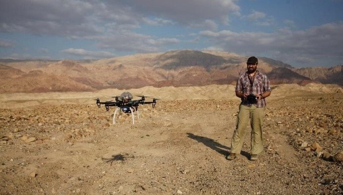
The survey of archaeological sites has always been gigantic. It is a process that takes much time in the process. This kind of change that has been observed is significantly less pronounced until the advent of contemporary technologies. For example, the drone. Recent drones with mapping capabilities are useful to state for modeling and surveying archeological sites. Archaeologists use drone mapping to obtain charts with well-defined and narrow accuracy. Ensuring the exploration procedure is quicker and more accurate.
Benefits of Drone Mapping
Drone mapping presents several advantages. 21st-century archaeologists can get many benefits from this technology when exploring sites. First of all, they may facilitate the receipt of maximum photographic quality of objects. And their environment from different positions. They make it easier to establish features that may otherwise be hard to note. This is due to other activities done on the ground which makes it difficult to get information. A drone can move closer to the site and get very good photos and videos. Without the site even noticing or being affected by any movements. It is doing something that cannot be achieved by any human explorer or any other tool.
How Drone Mapping Works
Archaeological drones, engaged in exploratory missions, rely on the ability to hover over a desired location. While taking many photographs. To obtain the map, one has to purchase the images and then merge them. It is done with the assistance of specially designed image-merging software. The generated maps are not only correct. But they also contain correct information and they are georeferenced. Resulting in correct coordinates placed. This precision is important to get the accuracy and, to capture the details of the site under study.
Importance of April Tags
These are known as special markers placed on the ground to guide the drone. It is a concept applied in the field by archaeologists to enhance the map obtained from the drone. These Tags are relatively small in size and are square. They share quite a resemblance to the QR codes in their appearance. These markers are placed on the ground to photograph the area around the archaeological site before the flight is made. When the drone photographs the ground, april tags help the mapping software to position the photograph. Also, they help to orient it accurately.
How April Tags Work
These Tags function in the same way as it is widespread in most mapping apps. In that, they establish a horizon upon which to navigate. They already have a code by which the software can recognize the pattern or logo of a certain one. These tags assist the software in identifying where within most of the pictures these areas are. As a result, it develops a richer map that has fewer errors. This innovation enhances the quality of the aerial photographs generated through drones.
Therefore, makes archeological documentation more accurate. For example, when evaluating an archaeological site, the experts decide to take aerial photographs of the territory using drones. So, these special markers will provide the best option for mapping the area. Since they can be strategically placed and thus, provide better details on the map.
Future Of Drone Mapping
In the future, we might find drone mapping as an essential technology applicable in various fields. Such as oil exploration, resource management, agriculture analysis, environmental monitoring, military purposes, and many others. Specific areas that have benefited immensely from drone mapping solutions are important. These include the use of a Special marker system in archaeological site exploration. It is safe, effective, and versatile in recording and analyzing historical sites. Without the need for physical contact with artifacts. Over the years, they are bound to become even more influential in this field. So, in the future technologies are trying to develop more updates to these systems and technologies. With time, we will see more advancements in this beneficial field.
Conclusion
Based on the analysis of the current state and archaeological research it is safe to say that the future of drone mapping is bright. The general quality and level of detail of the maps that are captured by the drones are also perfect. It is a benefit and we can expect better improvement with time. Moreover, with the special marker system, these maps will have higher accuracy. Which is very helpful for archaeologists.


